Risk
Our understanding of disaster risk is expanding as we experience and analyse the impacts and consequences of each disaster season in Queensland. Our awareness of what constitutes risk and the information and tools needed to effectively manage these changing risks is also improving. This means that our approach to understanding hazard risk management in Queensland also needs to evolve, so that we can ensure our information, intelligence and processes are up to date in supporting risk-based planning and decision making by all stakeholders.
The Queensland Government has delivered a suite of reforms to Queensland's disaster and emergency management system.
In line with these reforms, from 1 July 2024 the State-level hazard and risk functions previously performed by the former Queensland Fire and Emergency Services (QFES) Hazard and Risk Unit transitioned to the Queensland Reconstruction Authority (QRA). QRA is now responsible for leading state-level hazard and risk functions, including the design and delivery of a risk assessment tool, as well as a number of projects and activities relating to community awareness, engagement and education.
Hazard and Risk Assessment in Queensland
Until recently, the Queensland Emergency Risk Management Framework (QERMF) defined the process for disaster hazard and risk assessments in Queensland.
Following an independent review of the QERMF, the QRA is developing a new hazard and risk methodology and supporting GIS-based tool to replace the QERMF.
. The new risk assessment approach is intended to form part of a broader suite of risk identification and assessment products.
The key audiences for the new methodology and tool are local government disaster management officers, and Local Disaster Management Groups (LDMGs). The new resources are designed to assist these groups undertake high level hazard and risk assessments for their local government area that can inform risk-based disaster management planning through the local disaster management plan (LDMP) and risk reduction activities through a Local Resilience Action Plan (LRAP).
More broadly, it is also the tool by which future state-level risk assessments and risk reporting (such as the State Disaster Risk Report) will be prepared for communicating a statewide view of risks for priority hazards.
These new risk assessment resources are not intended to duplicate or override existing established risk management processes such as those undertaken in accordance with the Queensland Flood Risk Management Framework (QFRMF) Bushfire Risk Mitigation Plans, or the Coastal Hazard Adaptation Program (QCoast 2100).
A technical guide for the new methodology and user guide for the GIS-based tool will be available for those councils and LDMGs who wish to undertake an emergency risk assessment to inform their risk-based DM planning processes – such as updating their LDMPs, DDMPs and informing LRAPs. Over time, these new resources will be updated and improved through a process of continuous improvement, including regular updates of the underlying hazard and asset data available.
If you have any questions about the new Queensland hazard and risk assessment methodology, please contact the QRA team via Hazard.Risk@qra.qld.gov.au.
Transition from QERMF
The Queensland Emergency Risk Management Framework (QERMF) is being superseded by a new methodology and suite of resources developed by QRA. However, it is acknowledged that some stakeholders may have already commenced, or are in the process of updating, risk assessments based on the QERMF. In such cases, access to the original QERMF materials remains available via the links below:
- QERMF LOCAL Risk Assessment - Master Template
- QERMF DISTRICT Risk Assessment - Master Template
- User Guide - QERMF Risk Assessment Workbook
These documents provide the necessary guidance and tools to support the completion of QERMF-based risk assessments during this transition period.
Any questions or queries relating to the use of these resources should be directed to Hazard.Risk@qfes.qld.gov.au.
2023 State Disaster Risk Report and other risk assessments
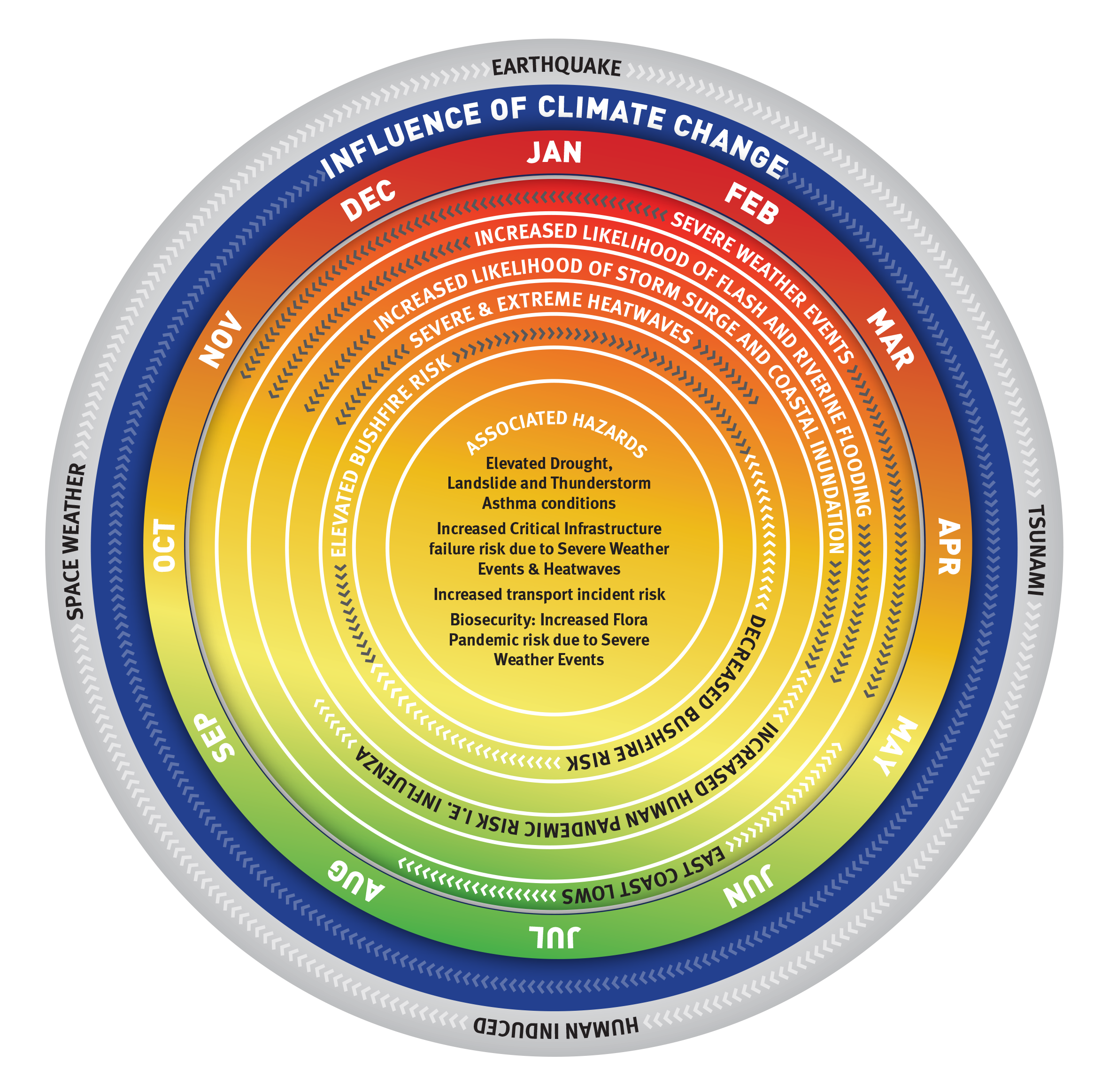
The 2023 State Disaster Risk Report (SDRR) provides an assessment of State-wide risk for ten hazards, two compound or cascading hazards, and a range of risk drivers. The 2023 SDRR also provides information on future climate and how this may impact future disaster risk for the State. The report advises decision-makers at all levels to consider the changing face of risk due to climate change, and to adjust their long-term disaster risk reduction planning where appropriate.
The SDRR improves Queensland's understanding of disaster risk and provides information for all entities with disaster management responsibilities to support decision making.
The existing state-Level risk assessments and reports outlined below, were developed by the Queensland Fire and Emergency Services (QFES) prior to the transition of the state-level hazard and risk function to QRA from 1 July 2024. All existing editions of the SDRR use the Queensland Emergency Risk Management Framework (QERMF) to assess these risks. In upcoming iterations of the SDRR, the new state hazard and risk methodology developed by QRA will be used to assess risks.
It is intended that updates to the State Disaster Risk Report will be prepared as new data and information becomes available and to consider emerging threats to the state’s disaster risk.
This 2023 update to the SDRR focused on three key aspects:
- to respond to the recommendation from the IGEM South East Queensland Rainfall and Flooding February to March 2022 Review to re-evaluate flood risk from all types of flooding,
- to incorporate new bushfire systems and data not available at the time of the 2021/22 Report, and
- to enhance the critical infrastructure failure chapter.

2023 State Disaster Risk Report: Executive Summary
2023 State Disaster Risk Report
Previous State Disaster Risk Assessments
2021/22 State Disaster Risk Report: Executive Summary
2021/22 State Disaster Risk Report
Queensland State Natural Hazard Risk Assessment 2017
Critical Infrastructure Disaster Risk Assessment
The Critical Infrastructure Disaster Risk Assessment (CInDRA) was developed as a detailed assessment of the critical infrastructure failure chapter of the State Disaster Risk Report (SDRR) developed by Queensland Fire and Emergency Services. The CInDRA is Queensland’s first state-wide critical infrastructure disaster risk assessment and was conducted in consultation with state government, local government, critical infrastructure operators and subject matter experts.
The intent of the report is to provide advice to agencies and organisations at all levels of Queensland’s disaster management arrangements, especially when they are undertaking disaster risk assessments. The CInDRA focuses on general trends and risks for critical infrastructure, it is not intended to be detailed and does not provide asset-level risk information. Local and district disaster management groups may use the CInDRA to understand how the risks may manifest at the scale most appropriate to them.
The CInDRA assesses climate and disaster risk for four critical infrastructure sectors: energy, water, transport, and communications. The assessment considers risks to these four sectors from all ten hazards in the SDRR with the addition of cybersecurity and space weather as these are recognised for creating significant risk within the critical infrastructure sectors.
While the risks within the CInDRA may seem easily apparent, this is the first iteration of a state-wide critical infrastructure disaster risk assessment for Queensland. The consideration of risk across the four sectors brings a shared understanding within and across sectors, acknowledging the interdependencies which exacerbate risk. This also highlights opportunities for research and development to advance efforts in critical infrastructure resilience, and to improve community outcomes during and after an event.
Critical Infrastructure Disaster Risk Assessment - Executive Summary
Critical Infrastructure Disaster Risk Assessment - Report
State Heatwave Risk Assessment
The Queensland State Heatwave Risk Assessment 2019 (SHRA) represents the most comprehensive analysis of future climate risk undertaken for a natural hazard risk assessment in Queensland. It is underpinned by a robust scientific basis, enabling all stakeholders including State agencies, disaster management groups, infrastructure owners and town planners to understand, plan for, and reduce the risk from heatwaves.
The summer of 2018-19 was the hottest on record for Australia. The extreme heatwaves and bushfires that occurred across Queensland are a clear indication that the State is facing unprecedented challenges in understanding and responding to the impacts of natural hazards in a changing climate.
The SHRA was developed to provide all stakeholders with clear and consistent information regarding the changing nature of heatwave risk in Queensland. It was a collaborative effort between multiple stakeholders, coordinated through a working group led by Queensland Fire and Emergency Services (QFES), Queensland Health (QH), and the Department of Environment and Science (DES).
The inclusion of long-term climate change projections within the assessment represents a first for hazard specific, emergency management related risk assessments in Australia. This robust scientific basis enhances the assessment and enables State agencies and disaster management groups to inform their planning against current and future heatwave risk.
Queensland State Heatwave Risk Assessment - Executive Summary
State Earthquake Risk Assessment and Tsunami Guide for Queensland
Originally published in 2019, the State Earthquake Risk Assessment (SERA) and companion Tsunami Guide for Queensland have been updated in 2024 to improve the information informing risk-based disaster management and business continuity plans at all levels of Queensland’s Disaster Management Arrangements. Detailed analysis of these hazards requires a high level of technical expertise. Queensland Fire and Emergency Services partnered with Geoscience Australia, the Queensland Department of Environment, Science and Innovation, The University of Queensland, and The University of Newcastle to undertake the update.
Some of the key updates of the SERA include:
- The inclusion of the new National Seismic Hazard Assessment 2023.
- New research re-evaluating the magnitude 6.0 Great Queensland earthquake from 1918.
- Review of past earthquake events and the inclusion of more Australian impacts, highlighting the significant impacts it can have on critical infrastructure, as well as the need to consider seismic activity in long-term planning decisions.
- More information on the services available from Geoscience Australia, including Earthquakes@GA, FeltGrids and ShakeMap products to improve awareness and inform risk planning.
A key finding of the 2019 SERA, which remains in the 2024 version, identified the area of highest earthquake risk In Queensland. This encompasses a large area in the State’s South East, from Gladstone in the north to Logan and Scenic Rim in the south, and from the coast across to the Burnett and Western Downs regions. This assessment considers the probability of earthquake occurrence in these areas, as well as the density of population, infrastructure, and economic activity in the area.
The Tsunami Guide for Queensland has also been updated and provides updated information on tsunami risk for Queensland, and analysis of events such as the 2022 Hunga Tonga-Hunga Ha’apai eruption.
State Earthquake Risk Assessment 2024
State Earthquake Risk Assessment 2024 - Executive Summary
Tsunami Guide for Queensland 2024
Tsunamis are rare but are a significant threat to Queensland’s coastal communities. This interactive Statewide mapping of tsunami evacuation areas can be used by all disaster management stakeholders to enhance warnings and risk informed planning for local communities.
This mapping was a collaboration between QFES, local governments, and partners at the Queensland Police Service, Department of Environment and Science, Geoscience Australia, and the NSW State Emergency Service. It identifies broad areas that should be evacuated in the event of a land inundation threat from tsunami, and also includes information on key exposures within these areas.
Tsunami evacuation areas for Queensland
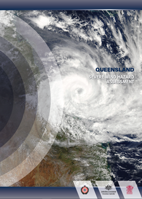
Severe Wind Hazard Assessment for Queensland
The Severe Wind Hazard Assessment for Queensland - SWHA(Q), was delivered as a collaborative project between Queensland Fire and Emergency Services (QFES), the Queensland Department of Environment and Science (DES), James Cook University and Geoscience Australia (GA).
Developed in response to the 2017 Cyclone Debbie Review, the projects core aim was to provide realistic and tangible information on the potential physical impacts of tropical cyclones on Queensland communities.
The suite of hazard management tools delivered through the project will enable the emergency management sector, local governments, and communities across Queensland to more effectively work through current and future risks posed by cyclones, including long-term strategic risk management strategies.
Severe Wind Hazard Assessment for Queensland - Factsheet
Queensland Government's Tropical Cyclone Hazard Dashboard enables users to interactively query the current and future risk of severe winds related to tropical cyclones across Queensland's regions and communities.
Tropical Cyclone Preparedness Guide
Severe Wind Hazard Assessment for South East Queensland
The Severe Wind Hazard Assessment for South East Queensland (SWHA-SEQ) project was developed following the conclusion of the Severe Wind Hazard Assessment for Queensland acknowledging the heightened risk in the South East Queensland region given the high exposure (large and growing population) and vulnerability associated with the building design standards for this region.
The project was a collaboration between six local government areas (Noosa, Sunshine Coast, Moreton Bay, Brisbane, Redlands and Gold Coast), Queensland State Government (Queensland Fire and Emergency Services, Department of Energy and Public Works, Department of Environment and Science, Department of State Development, Local Government and Planning, and Queensland Reconstruction Authority) Insurance Council of Australia, Insurance Australia Group Ltd, Suncorp, James Cook University Cyclone Testing Station, the University of Queensland and Geoscience Australia.
The project was delivered by the Geoscience Australia led research team including James Cook University Cyclone Testing Station and the University of Queensland.
Emergency Management Sector Adaptation Plan (EM-SAP) for Climate Change
As a part of the Queensland Government's climate change response, QFES led the development of a Sector Adaptation Plan for Climate Change in partnership with the Department of Environment and Science and the National Climate Change Adaptation Facility. This Sector Adaptation Plan has now been incorporated into the DM PPRR Guideline and therefore now can be considered a background resource.
Factsheets
EM-SAP
The Plan
Executive summary
EM-SAP by section below:
The science of climate change
Why is climate change important to the sector
Understanding disaster risk and disaster risk reduction are international priorities as captured within the United Nations Office for Disaster Risk Reduction Sendai Framework for Disaster Risk Reduction 2015-2030 "Priorities for Action".
Under the Queensland State Disaster Management Plan, Queensland Fire and Emergency Services (QFES) is responsible for the conduct of a State level disaster risk assessment. The Queensland Emergency Risk Management Framework (QERMF) has been developed to inform risk-based planning across the emergency management sector in Queensland and has been endorsed by the Queensland Disaster Management Committee.
The application of the QERMF promotes opportunities for collaboration and communication between Government, industry stakeholders and the community across the three disaster management levels (Local, District and State) in Queensland. It also promotes the need for identification and communication of residual risk across these levels.
The QERMF assists key stakeholders working within Queensland's Disaster Management Arrangements (QDMA) to review existing natural disaster risk management processes and assist in enhancing resilience as outlined within the Queensland Strategy for Disaster Resilience.
Proposals for amendment to the content of the Queensland Emergency Risk Management Framework are to be submitted via the Suggestions web form.
The resources contained within this section seek to aid disaster and emergency management practitioners in the implementation of the QERMF across Queensland’s disaster management arrangements. This “tool-kit” is maintained by the Hazard and Risk Unit, Queensland Fire and Emergency Services. Any questions or queries relating to the use or efficacy of these resources should be directed to Hazard.Risk@qfes.qld.gov.au.
Risk Assessment Process Handbook
The QERMF Risk Assessment Process Handbook provides a valuable risk assessment methodology that can be used within disaster management planning at all levels of Queensland’s Disaster Management Arrangements (QDMA) – Local, District and State.
The process applies a proven, standardised and internationally recognised approach to the prioritisation, mitigation and management of risk. This includes the identification and communication of residual risk across stakeholders and QDMA.
The process seeks to directly inform planning and resource allocation, and to promote active emergency management communication, cooperation and coordination.
This handbook outlines both the framework and approach for this risk assessment process in a step-by-step manner and provides examples, resources and templates to assist in its implementation.
Risk Assessment Process Handbook
Templates and User Guides
The templates and user guides provided below seek to provide a consistent format for the capture of risk information derived during the conduct of the risk assessment process. Intuitive and easy-to-use, the tools also allow for the communication of risk information to stakeholders for feedback, whilst providing a auditable mechanism for the communication of residual risk, through consultation, to the appropriate stakeholders across QDMA. User guides have been developed to aid in the use of these tools where necessary.
QERMF LOCAL Risk Assessment - Master Template
QERMF DISTRICT Risk Assessment - Master Template
User Guide - QERMF Risk Assessment Workbook
Questionnaires
The questionnaires provided here seek to assist the disaster management practitioner in gathering relevant information to support the risk assessment process and the development of an effective Disaster Management Plan.
The questionnaires act as a method of governance to ensure accountability through the risk assessment process and enable clear line of sight in the determination and communication of residual risk.
Where there is no provision of information from a stakeholder or entity who has responsibility for an element within the area under assessment, this can be noted as residual risk within the process and then transferred (where appropriate) to the next level of QDMA for action or awareness.
The first questionnaire seeks to guide a practitioner in the completion of an all-hazards assessment, where there is shared responsibility to plan for disaster/emergency related risk.
The second questionnaire will aid the practitioner in determining what functional requirements are needed to provide support to lead agencies in the management of a disaster or emergency e.g. an environmental disaster in the marine environment, in support of TMR as the lead agency as identified in the SDMP.)
The process for employing these questionnaires to support the conduct of the QERMF Risk Assessment Process is outlined in the traffic light diagram below.
Disaster Management Group Stakeholder Questionnaire
Primary and Lead Agency Questionnaire
Support tools and templates
LDMGs can use support tools and templates to provide further support and information to aid recovery in their communities.
The template below can be adapted to include local information.
Post-bushfire resources, useful information for impacted landholders
2023 State Disaster Risk Report
Under the Queensland State Disaster Management Plan, Queensland Fire and Emergency Services (QFES) is responsible for the development of a state level disaster risk assessment.
It is intended that updates to the State Disaster Risk Report occur as new data and information becomes available and to consider emerging threats to the state’s disaster risk.
This 2023 Report is an update to the 2021/22 Report focused on three key aspects:
- to respond to the recommendation from the IGEM South East Queensland Rainfall and Flooding February to March 2022 Review to re-evaluate flood risk from all types of flooding,
- to incorporate new bushfire systems and data not available at the time of the 2021/22 Report, and
- to enhance the critical infrastructure failure chapter.
This report improves Queensland's understanding of disaster risk and provides information for all entities with disaster management responsibilities to support decision making. As with previous Reports, the 2023 State Disaster Risk Report uses the Queensland Emergency Risk Management Framework (QERMF) to assess these risks.
As with the 2021/22 State Disaster Risk Report, the 2023 Report provides an assessment of State-wide risk for ten hazards, two compound or cascading hazards, and a range of risk drivers. The 2023 Report also provides information on future climate and how this may impact future disaster risk for the State. The report advises decision-makers at all levels to consider the changing face of risk due to climate change, and to adjust their long-term disaster risk reduction planning where appropriate.
2023 State Disaster Risk Report: Executive Summary
2023 State Disaster Risk Report
Previous State Disaster Risk Assessments
2021/22 State Disaster Risk Report: Executive Summary
2021/22 State Disaster Risk Report
Queensland State Natural Hazard Risk Assessment 2017
State Heatwave Risk Assessment
The Queensland State Heatwave Risk Assessment 2019 (SHRA) represents the most comprehensive analysis of future climate risk undertaken for a natural hazard risk assessment in Queensland. It is underpinned by a robust scientific basis, enabling all stakeholders including State agencies, disaster management groups, infrastructure owners and town planners to understand, plan for, and reduce the risk from heatwaves.
The summer of 2018-19 was the hottest on record for Australia. The extreme heatwaves and bushfires that occurred across Queensland are a clear indication that we are facing unprecedented challenges in understanding and responding to the impacts of natural hazards in a changing climate.
The SHRA was developed to provide all stakeholders with clear and consistent information regarding the changing nature of heatwave risk in Queensland. It was a collaborative effort between multiple stakeholders, coordinated through a working group led by Queensland Fire and Emergency Services (QFES), Queensland Health (QH), and the Department of Environment and Science (DES).
The inclusion of long-term climate change projections within the assessment represents a first for hazard specific, emergency management related risk assessments in Australia. This robust scientific basis enhances the assessment and enables State agencies and disaster management groups to inform their planning against current and future heatwave risk.
Queensland State Heatwave Risk Assessment
Queensland State Heatwave Risk Assessment - Executive Summary
State Earthquake Risk Assessment
The Queensland State Earthquake Risk Assessment 2019 (SERA) and companion Tsunami Guide for Queensland were developed to provide a comprehensive overview of earthquake and tsunami risk for the State. Detailed analysis of these hazards understandably requires a high level of technical expertise, so Queensland Fire and Emergency Services partnered with Geoscience Australia to help contextualise the findings of the National Seismic Hazard Assessment 2018 and the Probabilistic Tsunami Hazard Assessment 2018. Additional expertise was also drawn from Queensland Department of Environment and Science’s Coastal Impacts Unit, and The University of Queensland’s Julius Kruttschnitt Mineral Research Centre, who provided the Queensland context for each hazard.
The SERA has included occurrence probabilities for several timeframes for each source zone in Queensland, for a magnitude 5.35 (1989 Newcastle event) and 6.05 (1918 Gladstone event) earthquake. This is to highlight the significant difference in occurrence probabilities between these two events, as well as highlighting the need to consider seismic activity in long-term planning decisions.
A key finding of the SERA is that the highest risk in Queensland encompasses a large area in the State’s south east, from Gladstone in the north to Logan and Scenic Rim in the south, and from the coast across to the Burnett and Western Downs regions. This considers the probability of earthquake occurrence in these areas, as well as the density of population, infrastructure, and economic activity in the area.
State Earthquake Risk Assessment
State Earthquake Risk Assessment - Executive Summary
Earthquake Risk for Queensland: Webinar 2 June 2022
Tsunami Guide for Queensland 2019
Tsunami Risk for Queensland: Webinar 1 April
Severe Wind Hazard Assessment for Queensland
The Severe Wind Hazard Assessment for Queensland - SWHA(Q), was delivered as a collaborative project between Queensland Fire and Emergency Services (QFES), the Queensland Department of Environment and Science (DES), James Cook University and Geoscience Australia (GA).
Developed in response to the 2017 Cyclone Debbie Review, the projects core aim was to provide realistic and tangible information on the potential physical impacts of tropical cyclones on Queensland communities.
The suite of hazard management tools delivered through the project will enable the emergency management sector, local governments, and communities across Queensland to more effectively work through current and future risks posed by cyclones, including long-term strategic risk management strategies.
UPDATE 28 October 2022: The Severe Wind Hazard Assessment Executive Summary, Technical Report One and Technical Report Two have been updated to incorporate an improved understanding of the wind hazard which has resulted from the current Severe Wind Hazard Assessment for South East Queensland project

Severe Wind Hazard Assessment for Queensland - Factsheet
Queensland Government's Tropical Cyclone Hazard Dashboard enables users to interactively query the current and future risk of severe winds related to tropical cyclones across Queensland's regions and communities.
Tropical Cyclone Preparedness Guide
Videos
UPDATE 23 DECEMBER 2022: The Severe Wind Hazard Assessment for South East Queensland (SWHA-SEQ) project was developed following the conclusion of the Severe Wind Hazard Assessment for Queensland acknowledging the heightened risk in the South East Queensland region given the high exposure (large and growing population) and vulnerability associated with the building design standards for this region.
The project was a collaboration between six local government areas (Noosa, Sunshine Coast, Moreton Bay, Brisbane, Redlands and Gold Coast), Queensland State Government (Queensland Fire and Emergency Services, Department of Energy and Public Works, Department of Environment and Science, Department of State Development, Local Government and Planning, and Queensland Reconstruction Authority) Insurance Council of Australia, Insurance Australia Group Ltd, Suncorp, James Cook University Cyclone Testing Station, the University of Queensland and Geoscience Australia.
The project was delivered by the Geoscience Australia led research team including James Cook University Cyclone Testing Station and the University of Queensland.
Emergency Management Sector Adaptation Plan (EM-SAP) for Climate Change
As a part of the Queensland Government's climate change response, QFES has led the development of a Sector Adaptation Plan for Climate Change in partnership with the Department of Environment and Science and the National Climate Change Adaptation Facility. The plan outlines a vision, principles and a series of priorities that intend to guide sector climate change adaptation activities and planning to ensure that it is fully engaged with the risks and opportunities of a changing climate.
Factsheets
EM-SAP
The Plan
Executive summary
EM-SAP by section below:
The science of climate change
Why is climate change important to the sector
There are a number of on-going and one-off local and national grants available which can be used to fund (in-part or full) risk mitigation projects identified as an outcome of the QERMF risk assessment process.
Further information on available grants can be found through links provided below.
www.grants.services.qld.gov.au
www.communitygrants.gov.au/grants
https://qdosd.squiz.cloud/dsdti/local-government/for-councils/grants
Tsunami are a rare but significant threat to Queensland’s coastal communities. This interactive Statewide mapping of tsunami evacuation areas can be used by all disaster management stakeholders to enhance warnings and risk informed planning for local communities.
This mapping was a collaboration between QFES, local governments, and partners at the Queensland Police Service, Department of Environment and Science, Geoscience Australia, and the NSW State Emergency Service. It identifies broad areas that should be evacuated in the event of a land inundation threat from tsunami, and also includes information on key exposures within these areas.