Regional ecosystem framework
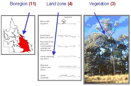
Each regional ecosystem is given a three part code, e.g. 12.11.3.
Bioregion
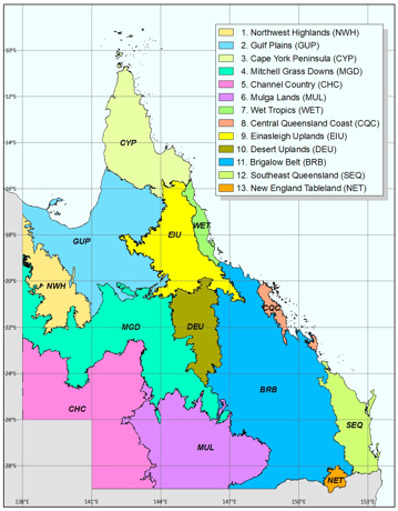
The first part refers to the bioregions and represents the primary level of biodiversity classification in Queensland.

There are 13 bioregions recognised in Queensland:
- Northwest Highlands (NWH)
- Gulf Plains (GUP)
- Cape York Peninsula (CYP)
- Mitchell Grass Downs (MGD)
- Channel Country (CHC)
- Mulga Lands (MUL)
- Wet Tropics (WET)
- Central Queensland Coast (CQC)
- Einasleigh Uplands (EIU)
- Desert Uplands (DEU)
- Brigalow Belt (BRB)
- Southeast Queensland (SEQ)
- New England Tableland (NET)
Land zone
The second part refers to the land zone that the regional ecosystem occurs on. The land zone is a simplified geology/substrate-landform classification for Queensland.
Vegetation
The third part is the ecosystem number and denotes different vegetation. Rainforest vegetation is classified and described using Webb's classification (Webb 1978). Non-rainforest vegetation structural classes follow a modified Specht (1970) system (Neldner, 1991). Plant names follow the current Census of Queensland Flora.
In the modified Specht (1970) system, the vegetation is described by the predominant strata, which is the one that is assessed as contributing the most above-ground biomass. The tallest strata is regarded as the emergent layer if it does not form the most above-ground biomass, regardless of its canopy cover, e.g. E. populnea trees above a low woodland of mulga. The height and cover of each layer is measured independently, i.e. separate height and cover values for the emergent (where present) and canopy layers.

In this example the unique number refers to a regional ecosystem, 11.4.3, which is found in the Brigalow Belt bioregion (region 11) that occurs on Tertiary clay plains (land zone 4) and which is usually vegetated with Acacia harpophylla and Casuarina cristata open forest (the third regional ecosystem described within the bioregion 11 land zone 4 combination).
The full description of this regional ecosystem also includes a range of associated species such as Eucalyptus woollsiana, E. populnea, E. cambageana, E. thozetiana and E. largiflorens. In low-lying areas Melaleuca bracteata may be locally dominant. Acacia harpophylla and Casuarina cristata occur together in other situations in the Brigalow Belt, for example, on alluvial plains and on fine-grained sedimentary rocks. These latter occurrences would equate to different regional ecosystems, specifically 11.3.1 and 11.9.5.
The above example demonstrates the importance of:
- accurately determining the land zone from geology or other available mapping such as soils and land system maps when using the regional ecosystem descriptions to verify mapping in the field, or when mapping in greater detail at a larger scale
- reading the full description of a regional ecosystem in the Regional Ecosystem Description Database and associated supplementary descriptions (a list of references is provided below), which may contain useful information to help interpretation. For example, species variation that may occur from place to place, a particular characteristic of landform or geology and understorey species that may be diagnostic.
Read the Queensland Herbarium methodology for mapping regional ecosystems across Queensland, for more information about the regional ecosystem classification and mapping, including interim numbering system for new regional ecosystems and map scale.
Training resource
The Regional Ecosystem Framework training and educational package includes a PowerPoint presentation, divided into 4 sections for ease of download, and a PDF file.
This is a resource for certified trainers and educators undertaking Regional Ecosystem Framework training. It should be used in conjunction with the competency standards for regional ecosystems.
Trainers may alter or use its contents as appropriate to meet their own training requirements as long as due acknowledgement is made.


