Photography and mapping
The department's first photographic services branch was established in 1880 by Surveyor General, WA Tully. The branch was established to utilise the available photographic technology for the production of maps, plans and trademarks for the department and the Patents Office.
Photographers were also sent to capture images of Queensland places and people. This resulted in an impressive image library capturing the history and development of Queensland.

Cameras
The original camera purchased to assist with the mapping process (unknown make, circa 1880) is believed to have been initially installed at the old Lands Office in George Street (immediately opposite Adelaide Street). It was recommissioned into the Executive Building when the department relocated there in 1905.
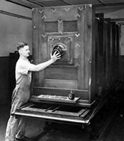
A replacement Hunter Penrose 35 x 45 inch Gallery Camera was ordered in 1923 and commissioned in 1924 on the 4th floor of the then Executive Building (later Lands Administration Building) adjoining Queens Park in central Brisbane.


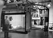
Due to their massive size and weight the Klimsch cameras were originally installed on the ground floor of the Lands Administration Building (now Treasury Casino Hotel), then in 1987 recommissioned into a purpose built facility in the Sunmap Centre (now Landcentre) at Woolloongabba. Photographic Services alone occupied 2,500 square metres and was the largest facility of its type in the southern hemisphere. Advancements in technology and the development of digital mapping lead to the decommissioning of the Klimsch cameras in 2007.
Related links
- Learn about Queensland’s mapping history.
- View images of instruments and equipment used to survey and map Queensland.
- Find out how to access the collection of historical Queensland photographs.