Hardships faced
Every profession has its drawbacks but surveying had more than most. As it is an outdoors occupation, surveyors were subject to nature's beasts. These ranged from crocodiles and snakes, right through to leeches, ticks, scrub itch, flies, mosquitoes and sand flies. These inhabited different parts of Queensland in different seasons. Flora in the form of prickly pear also made surveying difficult as did issues with water, whether it is too much or not enough.
Sandy blight
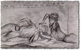
Sandy blight is a chronic eye infection often associated with poor hygiene or living standards and in some circumstances leads to blindness.

Road surveyor AC Macmillan, while working west of Townsville on the Burdekin River in 1866, gives a vivid description of the effects of sandy blight on himself and his assistant Alexander Jardine.
‘27 January 1866 – slightly better. About 10am, Mr Gary arrived and told me that Jardine was now two days bad with blight, camped six miles from this, and that the whole party were out of rations. None to be had here, decided upon sending the man on to the Range for flour, etc and first got him to start myself on the track with sulphate of zinc. Arrived at the tents somehow during the day. Found Alic as bad as myself, all but blind with nothing to eat – my ride in the sun having played the duce with my optics. Found it impossible to go back to the station, so stretched myself down and in spite of the intense pain, neither of us could help laughing when attempting to drop the solution into each others eyes. It found its way to the mouth instead ... some two days later. Sandy blight is a hundred times the most painful affliction a man can possibly have.’ (Macmillan, AC 1866, Letters to Byerley, Wor/A 68/26, Queensland State Archives)
With improved living standards Sandy blight had all but disappeared from Australia by the 1930s.
Nettles
Macmillan's job took him all over North Queensland locating roads through all types of country, including the rainforest areas behind Cardwell. In a letter to his boss, Fred Byerley, he describes the effects of the nettle tree:
‘The Scrub on Range is a dense scrub in which the Nettle or Stinging Tree flourishes, retarding the cutting of a track very much from the danger to man and horse if stung by it. It was in this scrub that the packhorse was stung, got mad, and died within two hours.’ (Macmillan, AC 1866, Letters to Byerley, Wor/A 68/26, Queensland State Archives)
Flies and mosquitoes
On the western plains in the 1880s, Surveyor GC Watson describes the effect of flies and mosquitoes on himself and his party:
‘In the approach of the rainy seasons in these parts the experiences of the traveller and residents are very unwelcome as regards flies, sand flies, and mosquitoes, the only successful remedy found being that of the smoke of cowdung. The flies will eat the eyes out of a horse's head, and when a dish of mutton chops are placed on the table, the chops become invisible through the swarms of flies thereon, so that the unwary bushman who fails to protect his eyes with a veil finds himself suffering from 'bung blight', which often times develops into sandy blight and severe ophthalmic diseases. Sand flies will run horses fifty miles off a station and scatter them all over the country. On one night our camp was overwhelmingly beset with mosquitoes, which bit through blankets and every other covering except our boots. The country not being stocked, there was no cow dung mosquito fuel available, and the atmosphere being calm, the mosquitoes were masters of the situation. At breakfast next morning I reminded my assistants that if John Wesley were present he would suggest that before eating, those who had indulged in profanity at the mosquitoes should wash their mouths, to which one of them unhesitatingly replied: “I would like to have seen John Wesley encamped here last night without cow dung.”’ (Watson, GC 1880, Typescript: Building the Commonwealth-Experiences of Forty Years in the Civil Service of Queensland, John Oxley Library)
Leeches
The continually wet rainforests caused Surveyor EM Waraker troubles while surveying along the Johnstone River in 1882:
‘It rains nearly every day. In fact I am always wet to above my knees. Leeches in the scrub very bad; my legs are all sore with them, as I can’t help scratching and the more I scratch the more I itch.’ (Waraker, EM 1882, Diary, John Oxley Library)
Prickly pear
Governor Arthur Phillip is credited with the introduction of a variety of prickly pear from Rio de Janeiro in 1787. He had hoped to establish a cochineal industry in the new colony in order to dye his soldiers' coats red. The crushed bodies of the female cochineal beetle make a red dye used for colouring material.
In order for the beetle to survive in Australia, Phillip had to introduce its food source: the prickly pear.
In 1884 a Brisbane newspaper reported large areas of infestation in the scrubs of the Darling Downs. However, it was not until 1893 that it was declared a noxious weed in Queensland.
In 1901, the Queensland Government addressed the problem of the pear by passing a private Bill. This legislated that selectors of prickly pear leases were only charged a peppercorn for rent. In return, selectors were to clear the land of pear.

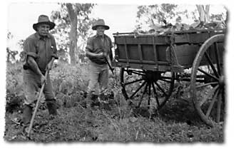
When the selections were surveyed, the dense pear formed an inhospitable barrier through which the surveyor had to clear his boundary line. Innovative surveyors had special leather suits tailored for them to wear while working in the pear, but some just put up with the prickly plant.
When hand-removing and chemical means proved too costly or unable to cope with the extent of the problem, a biological solution was sought and tested. The larvae of the cactoblastis moth proved successful in eating the pear and thus destroying it.
Difficulties encountered due to weather and excess rainfall
In the rainforests of tropical north Queensland, the surveyor and his men worked under extremely difficult conditions. The rain (up to 762 centimetres annually), made it almost impossible to work during the wet season (November to March).
In 1872, surveyor George Phillips carried out selection surveys on the Herbert River. He outlined in a report to the Surveyor General, AC Gregory, a list of problems that made it impossible to work in the area during the wet:
‘There are many things up here that make surveying work unpleasant, but I have sought in this report to confine myself strictly to that which makes it impossible.’
‘On reaching the open country, found it all under water ... waded the whole way seldom lower than the middle of the thigh, often to the arm pits – had to make many detours to avoid swimming.’
‘Apart from the unpleasantness of wading, this water so deep it is far from safe from the alligators [crocodiles] which are numerous avail themselves of the flooded state of the country ... I find that men cannot stand the constant exposure to wet they have to endure while working at this time of the year in the vicinity of the Herbert River.’
‘Started the day with one man, the rest down with fever.’
‘... I cannot accomplish the impossible.’ (Phillips, G 1872, Letter book diary, Museum of Lands, Mapping and Surveying)
In a later report, George Phillips reports on the death of a number of his chainmen:
‘I have had to sign for the man John Garside as the poor fellow died today from the usual low fever of these parts, after a short illness, this making the second man that has died in my camp within the last month. I may state that I cannot expect to do any work on the Herbert for some time yet, as it is merely throwing away men's lives to attempt it. The registered rainfall on the Herbert and at Cardwell for the month of January last was 37 inches.’ (Phillips, G 1872, Letter book diary, Museum of Lands, Mapping and Surveying)
Difficulties experienced with excess rainfall were not limited to the north of the colony. Francis Edward Roberts while surveying the Queensland – New South Wales border on the McPherson Range to the west of Tweed Heads, reported on the wear and tear on his equipment.
‘Then again from the nearly constant rain and moisture of these lofty and scrubby ranges, varying from 3000 to 5000 feet above the level of the sea, which were almost constantly capped with clouds. There was considerable wear and tear in my tents and packsaddles.’ (Roberts, FE 1865, Borders collection, Museum of Lands, Mapping and Surveying)
The McPherson Range section of the border survey was carried out between 27 April, 1863 and 1 May, 1865. During this time, 282 days were spent surveying. This meant that 145 days were lost to wet weather.
Too much water could also cause difficulties in moving the survey camp, as Surveyor John Cameron reported in 1880:
‘Had great difficulty in crossing creeks with the whole camp. The Irarah, Cuttaburra and Warrego being flooded. Irarah, being one mile wide and Warrego 20 chains wide, I had to construct two boats, one of planks and another of canvas and frame, the latter being the most useful; ferried eight tons with this boat in one afternoon including instruments.’ (Cameron, J 1880, Letters: Queensland NSW Border Surveys, Borders collection, Museum of Lands, Mapping and Surveying).
Coping with little water rations
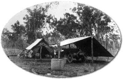
As most of the Australian continent is affected by long periods of drought, the availability of water to a surveyor and his team was a matter of life and death.
While surveying the Queensland-New South Wales border in 1880, John Cameron ended up sharing his remaining water with his horses:
‘At the 235 mile post, we nearly lost all our horses in one night (32) owing to ... being unable to find the waterhole ... Having 100 gallons of water in camp, I divided 50 gallons among the 32 horses with a little oatmeal which enabled them to travel to Warri Warri Creek ... I was obliged to give the horses a week's spell to recruit their strength.’ (Cameron, J 1880, Letters: Queensland NSW Border Surveys, Borders collection, Museum of Lands, Mapping and Surveying)
It was not uncommon for early surveyors in Australia to rely on local Aboriginal people to guide them to water. In times of extreme drought, surveyors had to postpone surveys in the affected areas for many years. This was because they were unable to provide enough water for their horses which they relied heavily upon. If they did work in drought affected areas, then a man's water would be rationed.
In 1886, surveyor Bedford allowed:
‘... one pint per man each morning and evening was the allowance for washing, and whenever it became exceptionally hot weather and thereby more than the usual quantity being used for drinking.’
‘I am afraid we often sacrificed cleanliness to thirstiness, and satisfied the needs of the inner man rather than the outer.’
‘Water was often obtained by sinking a cask in the sandy bed of the river.’ (Royal Geographical Society of Queensland 1886-87, Reminiscences of a surveying trip from Boulia to the South Australian border, vol. 2 no. 2, 1186-87, p. 103.)
Purifying water was also an option when the available supply was in poor condition. When working on the Moonie River in 1913, Surveyor Harold Leahy purified his 'extra thick and undrinkable water' by following the recipe:
‘... by mixing half a packet of Epsom salts and put in the kerosene bucket of water. Leave for some hours and then take off clear water carefully so as not to disturb the inch or so of sediment at the bottom, then boil the water for some time and skim off the green scum. It is then quite fit for use.’ (Leahy, HP 1913, Biographical file, Museum of Lands, Mapping and Surveying)
Once the Artesian Basin was tapped by the sinking of bores, surveyors were able to make use of the supplied running water to their front door for the men and animals.

Related links
- Learn about Queensland’s historical surveying processes.
- View images of instruments and equipment used to survey and map Queensland.